 Donations are greatly appreciated.
Hunter area Hiking
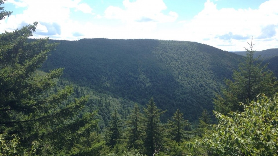
Hunter area makes a great "home base" for hiking the Catskills. This rugged countryside is crisscrossed with miles of trails, ranging from the well maintained network in and around North-South Lake to the rugged trails accessing the high peaks.
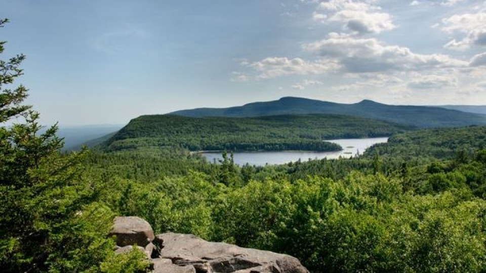
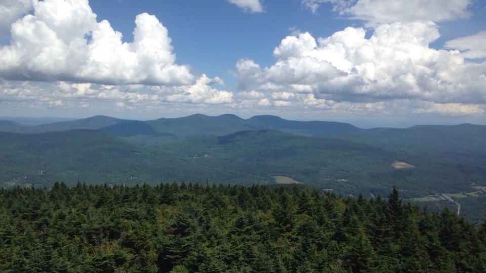
Hunter is a massive mountain that presents a number of different personalities. The north side is a heavily developed ski resort; the south side is rugged wilderness; and in between is the summit, with its cozy cabin and lofty fire tower. At 4040 feet in elevation, it is the second highest mountain in the Catskills.
Hunter Fire Tower
Look down on skiers at Hunter Mountain Ski area from the fire tower at the summit of Hunter Mountain. Multiple trails provide access to Hunter’s summit.
Historically more than a hundred towers, some built nearly a century ago, were used for early detection of forest fires throughout New York state because of their extensive views of the surrounding countryside.
Today, just five towers remain in the Catskill Park and are maintained with assistance from a dedicated group of volunteers and the New York State Department of Environmental Conservation. One of those 5 is the fire tower in Hunter.
During the summer months volunteers open up the tower cabins for visitors to enjoy the stunning panoramic views of the region. The five towers make for some of the best hiking destinations in the Catskills, offering unparalleled 360-degree views of the surrounding Catskill Park and mountains. They are well worth the time and effort it takes to hike to each tower. For more information on all 5 towers please see The Catskill Center Firetower Project
The Hunter Mountain Fire Tower is located at the highest elevation of any fire tower in New York State - on the summit of Hunter Mountain at 4040 feet. The original tower was constructed from logs and the current, 60-foot steel tower was constructed in 1917 about a third of a mile from the present location. In 1953 the tower was relocated to its current location on the summit of Hunter Mountain.
Hiking Directions: Take the blue-marked Spruceton Trail from Greene County Route 6 (Spruceton Road) in the hamlet of Spruceton for a seven-mile moderately difficult roundtrip hike. Or take the yellow-marked Colonel's Chair trail from the top of the Hunter Mountain Sky Ride, a moderate four-mile roundtrip hike.
There are a number of trails that crisscross Hunter Mountain so be sure to have a good trail map.
The easiest trail to Hunter Mountain Fire Tower starts at the Hunter Mt. Ski center chairlift on its way to the 60-foot steel tower built in 1917. The tower can be climbed to just below the cab. Go 1.1 miles to the intersection of the yellow-marked trail with the blue disks of the Spruceton Trail, then make a left and proceed 1-mile to the Hunter Mt. Fire Tower.
Distance: 4.2 miles Ascent: 900 feet.
Trails also reach the Hunter fire tower and summit: 1) via Spruceton (Greene County Route 6, Spruceton Road, off Route 42-see Diamond Notch Falls below. This trail is a 7-mile moderately difficult hike on an old woods road marked with blue disks); 2) via Diamond Notch, Stony Clove Notch or Becker Hollow (These trails are off Route 214, connecting Phoenicia-Route 28- with Route 23A, between Hunter and Tannersville). Stony Clove and Becker Hollow are very steep/very difficult and not recommended for children.
More information and photos
Click here to view Hunter Mountain Fire Tower Map
Hunter Mountain Loop - 8.16 mile trip - 5.75 hours. Moderate. Nice easy walk on the North side and Moderate walk on South side.
Hunter Mountain from Becker Hollow - 5.40 mile trip - 4.50 hours. Difficult. Starts off easy.
Hunter West Kill Wilderness -There are five named mountain peaks - West Kill (3,880'), North Dome (3,610'), Sherrill (3,540'), Balsam (3,340'), and Sheridan (2,220'). This area serves as watersheds for two New York City water supply reservoirs, the Schoharie and the Ashokan.
Becker Hollow Parking Lot is located on NYS Route 214, 1.3 miles southwest from its intersection with NYS Route 23A. (42.181339°N, 74.196415°W)
Diamond Notch Carriage Road - 5.37 miles round trip, blue markers - 2.75 hours. Easy. This trail is very old. The trail first existed for the Mohawk Indians who used it to travel from valley-to-valley. The Diamond Notch trail was once a road converted into a trail in the 1930s. The trail extends south from Spruceton Road through Diamond Notch, and descends down to connect with Diamond Notch Road. At 1 mile, the trail passes Diamond Notch Falls and the intersection with the Devils Path. At 2.2 miles, the trail passes a lean-to and the diamond notch.
Diamond Notch Parking Lot is located near the end of Spruceton Road, 6.8 miles from its intersection with NYS Route 42. (42.182385°N, 74.269997°W)
South Diamond Notch Parking Lot is located on Diamond Notch Road, 1.2 miles north from its intersection with NYS Route 214. (42.147861°N, 74.264659°W)
Devil's Path (25.2 miles, red markers) - popular and challenging trail extending from the Prediger Road Parking Area in Indian Head Wilderness west to County Route 6 (Spruceton Road) in the Hunter-West Kill Wilderness. Devil's Path is one of the most popular trails in Catskill Park. The trail crosses the summits on Indian Head, Twin, Sugarloaf, Plateau, and West Kill mountains. About 11.4 miles of the trail traverse the northeast portion of the Hunter-West Kill Wilderness.
Devils Path Trailhead Parking Lot is located on Spruceton Road, 3.8 miles from its intersection with NYS Route 42. (42.192019°N, 74.323847°W)
Kaaterskill Falls Trail, Kaaterskill Wild Forest - The 7,620-acre Kaaterskill Wild Forest, located in the Catskill Forest Preserve is a popular destination for outdoor recreation, due to the abundance of hiking and other recreational trails available, as well as the iconic Kaaterskill Falls. The terrain within Kaaterskill Wild Forest varies significantly in topography with sprawling mountains, dramatic cliffs, scenic waterfalls, and deep valleys. The area is occupied by deciduous and boreal forest species as well as an abundance of other plants and wildlife.
Parking is uphill (to the west) of the junction of Rt 23A and Kaaterskill Creek. At 260 feet, these are the highest waterfalls in New York State, dropping in two tiers - the upper falls 175 feet and the lowers falls 85 feet into a rocky basin. They were often painted by artists of the 19th century Hudson River School of Landscape Painters. From the parking lot, walk down hill along the north side of the road across the Bastion Falls bridge and turn left onto the yellow trail. The trail climbs steeply from the road, with several good spots to view Bastion Falls, then following the stream through mixed hardwoods and hemlocks to the base of Kaaterskill Falls. The trail is moderate, with some steep ups and downs. After crossing several rock slides, the trail passes large 200+ year old hemlock trees on its way to the often mist-shrouded base of the falls. For your safety, please stay on the trail and do not hike beyond the end of the trail. Do not attempt to climb the falls as this is dangerous.
Kaaterskill Falls Trail (0.5 miles; elevation gain: 445 feet, loss: -112 feet). Access the trail from the Molly Smith parking area on the south side of route 23A. The trail head is located 0.2 miles down the road from the parking area. From the trailhead it is 0.5 miles to the base of the iconic 260 foot tall Kaaterskill Falls. There is a moderate climb for the first 250 ft, the trail then levels off to a gentle climb following the creek.
Long Path - backpacking trail that extends through the Catskill Forest Preserve. The trail traverses the Kaaterskill Wild Forest and connects to the adjacent Indian Head Wilderness to the south and Windham-Blackhead Range Wilderness to the north. In the northern section of the Kaaterskill Wild Forest the path follows the Harding Road Trail and the Escarpment Trail. It continues to follow the Escarpment Trail into the Windham- Blackhead Range Wilderness.
Kaaterskill High Peak Trail (6.5 miles; elevation gain: 911 feet, elevation loss: -904 feet) - snowmobile trail encircles Roundtop Mountain and Kaaterskill High Peak. It connects with the southern portion of the Long Path. This trail is open to hikers, mountain bikers, and horseback riders in the warm months. From the south the trail is accessed from the Steenburg Road parking area off of Platte Clove Road. Follow the Long Path (blue markers) north. Take a left at mile 3.4 and connect to the Kaaterskill High Peak Trail. The trail curves west, and wraps around Kaaterskill Peak and Roundtop Mountain. Note, reaching the actual summit of Kaaterskill High Peak require using an unmarked herd path that DEC does not maintain.
Huckleberry Point Trail (2.4 miles, elevation gain: 644 feet) - The trailhead is accessed from the Steenburg Road Parking Area off of Platte Clove Road. From parking head north following the blue markers up the Long Path. At the 1-mile mark go right (east) on the Huckleberry Point Trail. Follow the Huckleberry Point Trail's yellow markers 1.4 miles for rewarding views of the Hudson Valley,Overlook Mountain and peaks in the Indian Head Wilderness to the southwest.
Sleepy Hollow Horse Trail (4.9 miles) - horse trail runs north to south along the eastern border of Kaaterskill Wild Forest. Open to hiking, marked with red trail markers. It connects the Long Path with the Mountain House Turnpike wear Rip Van Winkle Historic House site is found.
Poet's Ledge (3.6 miles, elevation gain 1,661 feet) - Access the trailhead from the Harding Road Parking Area located off of NYS Route 23A. From the parking area follow NYS Route 23A west to Malden Ave, follow the trail past the barriers. From the parking area the trail follows the Long Path for the first 3.0 miles. At mile 3.0 take a right and travel 0.5 mile north to Poets Ledge.
Buttermilk Falls (also 4.8 miles) - scenic waterfall located on the Long Path. Falls can be reached from the south (4.8 miles) starting from the Steenburg Road Parking Area off of Platte Clove Road or the east (same distance) starting from the Harding Road Parking Area located off of NYS Route 23A in Palenville.
Escarpment Trail (9.8 miles in the Kaaterskill Wild Forest, 23.9 miles total) - trail runs from the Schutt Road Parking Area in the Kaaterskill Wild Forest north along the northeast corner of the Catskill Mountains through the Kaaterskill Wild Forest, Windham Blackhead Range Wilderness, and Elm Ridge Wild Forest, ending at the Route 23 Parking Area in the Elm Ridge Wild Forest. From Schutt Road Parking Area cross the road and follow the blue trail markers. At mile 0.5 the trail intersects with the Schutt Road Trail. To continue on the Escarpment Trail follow the blue markers. At mile 1.2, the reaches Layman's Monument, a tribute to an early 20th century fallen firefighter, and turns sharply east. At mile 1.65, the trail intersects a yellow blazed trail that would lead to the Schutt Road Trail. Continue on the Escarpment Trail to mile 1.75 to reach Sunset Rock and mile 1.9 for Inspiration Rock, both with scenic vistas of the Kaaterskill Clove and Kaaterskill High Peak. At mile 2.7 the trail joins the Sleepy Hollow Horse Trail briefly, then meets Long Path and turns left and ascends, northward toward South Mountain. At mile 3.15 there is a junction with the Schutt Road Trail on the left (west). The Escarpment Trail turns east. At mile 3.8 there is a red marked trail that bypasses Boulder Rock. Following the Escarpment Trail, Boulder Rock is at mile 4.0. The site of the former Catskill Mountain House is at mile 4.5. At mile 4.75 there is the Parking area at North South Lake Campground. Follow blue discs. At mile 5.25 is Artists Rock with its excellent views of the Hudson Valley. At mile 5.75,n your right is a yellow blazed side trail that leads to Lookout Rock and 0.2 mile to Sunset Rock. This is another Sunset Rock. Mile 5.95, reachNewman's Ledge with more excellent views of Hudson Valley.
Catskill Mt. House Site, North-South Lake
Enjoy swimming, fishing and boating or take a hike. Start with a short hike to one of the most beautiful views of the Hudson Valley, the former site of the Catskill Mountain House. On a clear day you can see five states. In its heyday, between the 1850s and the 1870s, this renowned hotel catered to 400 guests a night, including such notables as Presidents Arthur and Grant. Picture guests sitting on the long 13-column porch enjoying the panoramic view. Walk east to the ledges of the escarpment wall, called the Wall of Manitou by Native Americans who believed it was the dwelling place of Manitou, their God. Study the carvings in the red sandstone rocks and see how many dates from the 1800's you can find.
Take 23A to Haines Falls, then follow signs to North-South Lake Campground. Drive through the North Lake Beach parking lot and park in the gravel lot just beyond (The area is open May-October when a day-use fee charged. Access at other times is free, but the hike is longer, about 2 miles from South Lake dam parking lot.). Walk uphill through the lot looking for the blue trail markers and a sign directing you to turn right. Follow the blue markers uphill for .2 miles to the open ledges of this famous spot.
Distance (Mt. House): .5 mile. Ascent: 80 feet.
The campground offers access to numerous hiking trails. The short hike is to the site of the Catskill Mountain House. Longer and more strenuous hikes can bring you to such spots as Artist's Rock, Sunset Rock, Newman's Ledge, Boulder Rock, and the Kaaterskill Hotel and Laurel House sites. Kaaterskill Falls lies outside the campground and is reached by a trail beginning on Route 23A.
Alligator Rock and Boulder Rock, North-South Lake
Alligator and Boulder Rocks are glacial erratics (boulders left behind 10,000-12,000 years ago when the mile-deep glacial ice sheets receded). There are many erratics throughout the Catskills. Go back to the gate at the end of the parking lot and follow the old carriage road (marked with red snowmobile trail markers) for a gentle hike to Alligator Rock. Hikers can also take a circular route by heading to the South Lake picnic shelter and following the trail past Alligator Rock back to the parking area. Distance (Alligator Rock): 1.0 mile. To get to Boulder Rock, take the Blue Escarpment Trail which starts near the Catskill Mountain House site historical marker. Views toward Palenville and Hudson Valley. Distance: 1.5 miles. Ascent: 200 feet.
Mary's Glen and Ashley Falls, North-South Lake
This hike starts a little rough - on a cobbled streambed. However, it's a good hike for parents with small children who want to avoid hiking near open ledges. The short, easy hike take you through a lovely wooded glen alongside a beaver meadow to the base of a heavily forested cascade known as Ashley Falls. The place name, Mary's Glen, remembers Mary Scribner, whose husband, Ira, once operated a saw mill on the creek. As you enter North-South Lake Campground trailhead parking cross over the stone bridge and turn right, following the red markers and a sign directing you to North Point and Mary's Glen. At 0.2 miles the yellow spur trail leads straight ahead (sign says Ashley Falls) 0.1 mile to the rocky base of the falls. Distance: 0.6 miles. Ascent: 20 feet.
Artist and Sunset Rocks, North-South Lake
A favorite stop for such artists as Thomas Cole in the mid-1800s. Their paintings are found in museums throughout the world in what is today known as the Hudson River School of Landscape Painters. This hike has narrow ledges and mostly gentle climb with two steep segments, through a forest of flat rocks and pines. Begin this hike at the bulletin board just before you get to the North Lake Beach Parking. A short connector trail with yellow markers leads into a pine forest and joins the escarpment trail at .01 mile where you turn left and follow the blue trail markers. Here you find a trail register. There is a steep scramble over boulders up to a ledge at 0.2 mile. Following the ledges over flat slabs of rock and passing through the pitch pine forest, brings you to many good views before a short, steep segment brings you to Artist Rock ledge at 0.3 mile. Distance - 0.6 miles. Ascent - 200 ft. After an easier stretch and another short climb, take the yellow trail at the junction to Sunset Rock for magnificent views of North and South Lake and the Hudson River. Distance: 1.6 miles. Ascent: 300 ft.
Colgate Lake, Colgate Lake Wild
Town of Jewett, Greene County The 1500-acre Colgate Lake Wild Forest features the scenic Colgate Lake, a popular lake for fishing, kayaking and primitive camping. The yellow marked Colgate Lake Trail travels just over 4 miles to Dutcher Notch and the Escarpment Trail. The wild forest is surrounded by the Windham Blackhead Range Wilderness Area on three sides.
Colgate Lake Wild Forest is open to hiking and other non-motorized recreation. You can Canoe or paddle the 26-acre lake. Mountains surround the valley, with good views of the Blackhead Mountain Range (Thomas Cole 3940 feet, Black Dome 3980 feet, Blackhead 3940 feet). The Colgate Lake Trail (yellow markers) from the last parking lot takes you to a beaver wetland (at 2.35 miles) and meadow - site of a vanished village and sawmill where Dutch settlers, Esopus Indians and runaway slaves lived 200 years ago. You can hike onward across the mountains down to the Hudson Valley. Distance: From parking lots to the lake is less than 1 mile.
More Useful links:
Rules, Regulations and Outdoor Safety
Practice Leave No Trace (leaves DEC website) principles when recreating in the Catskills to enjoy the outdoors responsibly; minimize impact on the natural resources and avoid conflicts with other backcountry users.
All users of Hunter-West Kill Wilderness must follow all State Land Use Regulations and should follow all Outdoor Safety Practices for the safety of the user and protection of the resource.
Specific Rules
Camping is prohibited above an elevation of 3,500 feet in the Catskills, between March 21 and December 21.
related activities
featured properties
Catskill Bungalow Tiny House Vacation Rental

Catskill Getaway Apartment
Catskill Cottage Vacation Rental
Domeo - Romatic Magical Dome in the Catskills!